WVUA coverage of the June 22 presentation on the 1887 Tuscaloosa panoramic map ROBERTOREG June 22 Jemison House Presentation - YouTube
Historic Tuscaloosa kicks off summer lecture series - WVUA 23

Transcribed from the Thursday, June 22 WVUA 10 o'clock NEWSCAST:
"I want to show people how they can use that map to learn everything they want to know about Tuscaloosa, not from 1887 but from 1821 until 2023 because the street grid on that map is unchanged since 1821." ~ Robert Register
"Register's lecture consisted of the history of the state, the first sale of land in Tuscaloosa and what has changed since. Register's knowledge of details pertaining to the map is unmatched. He shared information of who lived in each house and what businesses used to be here." ~ Nick Ballenger of WVUA-TV
"I know Robert Register who probably knows as much about Tuscaloosa history as anyone in Tuscaloosa." ~ Brock Jones, member of Historic Tuscaloosa


ON CREATING AN EXHILARATING NEW VISION OF ORIGINAL TUSKALOOSA
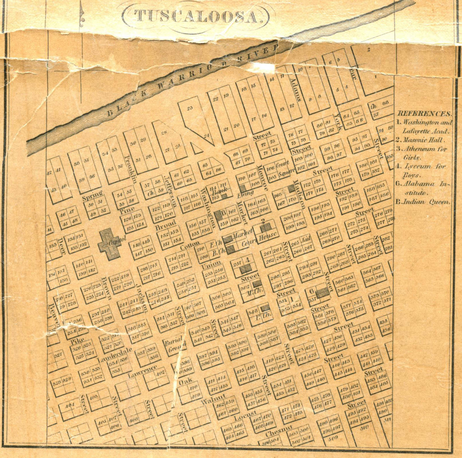
I promised your organization that my presentation would show y'all how an old lithograph called the 1887 PERSPECTIVE MAP OF TUSKALOOSA, ALA. can become an educational paradigm that will get people excited about Tuscaloosa's two-centuries old story and that researching this old map will enhance the future of historical learning, or any other learning, for that matter.
They say that maps show us the face of history. That's especially true of illustrated maps such as Henry Wellge's 1887 Tuscaloosa panoramic map. My hope is that the work I've done producing an annotated key for this map along with related images will be picked up by others and expanded upon because this bird's eye view lithograph represents the summation of the 7 decades of events which occurred on our sacred one-square mile of land from the time of the laying out of our present-day city street grid in 1821 to the drawing of the Wellge map in 1887. All our work on this map will serve others as a baseline through which any of us can open a window into time to catch a fleeting vision of some of the important events which have occurred here during the past 202 years.
Prior to the advent of aerial photography in the 1920s, maps like our 1887 map went by many names. They were called "bird's eye view" maps, panoramic maps, perspective maps or aero view maps. The purpose of these maps was to attract prospective residents, businesses and investors by showing them a comprehensive view of street patterns, individual buildings and major landscape features.

%20-%20Copy.jpg)
.jpg)
%20-%20Copy.jpg)
.jpg)
%20-%20Copy.jpg)
Making one of these required knowledge of landscape painting, military mapping and property ownership surveying. The Library of Congress has over 1500 of these North American panoramic maps and 55 per cent of them were produced by only five men. German native Henry Wellge (1850-1917) was one of those five and he drew over 150 of these maps. Six of Alabama's ten panoramic maps were drawn by Wellge in 1887 and 1888: Birmingham, Gadsden, Montgomery, Selma and Tuscaloosa.
During the last half of the 19th century over 200 of these panoramic maps were printed showing the State of New York's cities and towns. 25 of them were made just for New York City alone. 135 of these maps were drawn for Massachusetts cities and towns but very few were made for Southern towns and cities. That might have been because the South was more rural but it also may have had something to do with the poverty of the region after the Civil War and Reconstruction. The artists themselves may not have been interested in working in the South because they feared prejudice against Northerners. Three of the most prolific American panoramic map artists served in the Union Army during the Civil War. During their military service, they learned military topography skills as well as naval cartography. Wellge learned these skills while serving in the engineer corps of the Prussian Army. He apparently immigrated to this country in 1878. A May 25, 1890 clipping from the SALT LAKE CITY HERALD states that Wellge was "considered the best perspective artist in the country." Wellge was noted for his "large dramatic views with emphasis on the horizontal dimensions."


Before discussing Wellge's work in Tuscaloosa, it is important to give you some background information to help you better understand what led this mapmaker in 1887 to use his vivid imagination along with some sophisticated geometry to draw an imaginary aerial view of Alabama's former capitol city located at the point where navigation up the river from Mobile ended below the first bluff rising up from the south side of the Warrior.
Of course, the Creek Indians lost their claim to Tuscaloosa's land after their 1814 defeat at Horseshoe Bend which forced them to extinguish their title by signing the Treaty of Fort Jackson. This land was also claimed by the Choctaws but two years later, in October 1816, the Choctaws lost their claim to this land when one of the founders of Tuscaloosa, Colonel John McKee, had the Indians sign the Treaty of the Choctaw Trading House. That treaty extinguished all Indian title and opened this territory up to settlers and they poured in.
A little over a month after the signing of the Choctaw treaty, on December 6, 1816, James O. Crump wrote a Letter to the Editor of the Huntsville Republican describing his trip from Mobile to Huntsville via the Warrior River and the Falls of the Black Warrior. Using his 35 foot keelboat and two wagons each pulled by four horse teams, Crump described how he was able to get two wagon loads of Cuban sugar, wine, coffee and oranges safely to Huntsville. Crump was especially proud that of his cargo of 1000 Cuban oranges, only about a half dozen spoiled during the trip from Havana to Mobile and then up to Huntsville. The Huntsville newspaper ran his letter with an introduction headlined "NEW CHANNEL OF COMMERCE."

Suddenly "the Falls of the Black Warrior" were the talk of the entire nation as Southern newspapers along with ones in Philadelphia, Annapolis and New York City reprinted the Huntsville Republican story.
Beginning in January, 1817, U.S. newspapers reprinting the Crump article had the entire English-speaking world looking at opportunities to make money in this unknown land which, since 1798, the U.S. had called the Mississippi Territory and during the last days of President Madison's administration, demands poured into Washington, D.C. for the President to do something about getting this wilderness acreage surveyed and auctioned off as soon as possible.
On March 3, 1817, the last day of President Madison's administration, the President signed two bills that would seal present-day Tuscaloosa's fate. One bill authorized the Mississippi Territory to be split into two parts with the western section being made into the State of Mississippi and the eastern section to be called Alabama Territory. This arrangement was supported by the citizens of Mississippi Territory because the division would result in the creation of two more U.S. senators and a few more Congressmen who would be there to support "the peculiar institutions of the South" in the nation's capital.
A second bill signed by President Madison during his last day in office authorized the creation of a Surveyor General for the northern part of the Mississippi Territory and ordered the public land surveys of North and South Alabama Territory to be completed and that a point be set on a line through Fort Williams which was between present-day Montevallo and Sylacauga where those two surveys would meet. This line would become known as the Freeman Line and it cuts through Tuscaloosa County just north of Moundville.


In addition, this bill reserved from public sale township sections of one square mile from no more than ten different 36 square mile townships.
.jpg)
As with anything connected to government, progress in getting Tuscaloosa's land surveyed into city blocks and lots took a lot of time and in 1820 this resulted in the creation of a rival community in the township section west of the one reserved for a town in the 1817 bill. This was Newtown which was eventually incorporated into the town in 1826. Only a small eastern area of township section 21 which contains Newtown was included on the 1887 map.
Finally on August 23, 1821, the town survey of Tuscaloosa was completed and President Monroe ordered 511 town lots comprising the town of Tuscaloosa be sold to the public on October 29 of that year. Most of these half acre lots were located in groups of four on identical 2 acre rectangular city blocks. This was the origin for our present-day street grid for the original town of Tuscaloosa.
Thomas P. Clinton, Matt Clinton's father, published an article about Tuscaloosa's public streets and roads in the April 12, 1925 issue of the Tuscaloosa News. Clinton states that the first mention he could find for a Tuscaloosa street name was for Broad Street, present-day University Boulevard, in a December 30, 1822 legislative act passed in Old Cahaba establishing a public road to Jones Valley. This act stated that construction of this public highway would start "beginning from the east end of Broad Street in the Town of Tuscaloosa." According to Clinton, we find the first mention of Market Street, present-day Greensboro Avenue, was in a January 1, 1823 act passed in Cahaba which proposed moving the route of the Greensboro Road between town and Taylorville. The new route was to begin where the old route began "commencing at Market Street."
According to a November 28, 1903 Birmingham News article, "on May 24, 1824, Congress granted to the corporation of Tuskaloosa a title to the public streets and other rights of the general government in the land composing the city."
The oldest Tuscaloosa street map I have found is on the 1835 John LaTourrette map of the State of Alabama and West Florida. It does not include the two North to South streets or the single East to West street which were run along the section lines. These streets are present-day Martin Luther King, Jr. Boulevard, Queen City Avenue and 15th Street. In 1835 and in early 1887, these streets were called West Margin Street, East Margin Street and South Margin Street.
.png)

In late 1887, the name of East Margin Street was changed to Queen City Street and the name of South Margin Street was changed to Crescent City Avenue. The city made this change to promote the recently improved railroad connection between Cincinnati and New Orleans which was called the Queen & Crescent Route.

I left my hometown of Dothan in 1968 and came to Tuscaloosa to go to the University so I've been walking the sidewalks next to the streets on the 1887 map for over half a century. I remember Tuscaloosa celebrating its sesquicentennial in 1969. Dothan didn't have a centennial until 1985 so Dothan was only about two years old and nothing more than a few shacks at a crossroads in the piney woods when the 1887 map was published. Only through preparation for this speech did I discover Tuscaloosa's importance in the founding of Dothan along with the success Dothan experienced during its railroad boom town era before WWI. That discovery which occurred while I was preparing for this presentation brought me unexpected joy and now I can't thank Historic Tuscaloosa enough for this opportunity to speak.
There are not that many places in Alabama as far away from Tuscaloosa as Dothan. I was 18 years old before I ever set foot in Tuscaloosa and I had no familial connections to the town but I'd heard about Tuscaloosa all my life. When I was a little boy growing up, folks used to tell me all the time, "Bob, if you keep actin' that way, they gonna send you to Tuscaloosa." so I guess the homefolks were right.
About 20 years ago, the Tuscaloosa News had a promotion where they asked their readers to write the paper and tell them why you loved T-town. I think there were some "I 'heart' T-town" bumper stickers that were part of the promotion. I sent in an entry and it was the last one of all the ones they published and I liked that. It went like this:
Standing on an old street corner laid out in 1821
Shaded by Druid oaks all around.
That's why I love T-town.
Sitting on a sandy bank
With my feet in the river
While the sun goes down.
That's why I love T-town.
Now that I've entered retirement, the "Why I love T-town" composition I wrote over 20 years ago summarizes my idea of a "perfect day." Spending my days walking the old streets of T-town and then heading to the river to feed the fish is my idea of a perfect day. I thank the Good Lord for allowing me to live this long and even though my old body's givin' out on me and the Lord's about to call me home, I still hope I'm granted a few more days and nights to walk T-town's streets and to explore its river banks and swamps.
I've been pretty serious about learning as much as I could about Tuscaloosa's streets and buildings since the publication of a little book your organization had printed in 1978 called PAST HORIZONS. Seeing as it's only three years from next month that the United States will be celebrating our semiquincentennial or 250th anniversary, it'd be a good idea to put out a new edition of that little book soon.
I'll never forget getting out my notebook and making an 1820s page and an 1830s page and an 1840s page and so forth and going through PAST HORIZONS and listing the buildings as to their construction date. That's when I figured out how to read Tuscaloosa addresses. I found as I walked down the street, the number of the avenue you crossed as you headed west or the number of street you crossed as you headed south along an avenue determined the first house numbers for each address on the next block. I also found that the even numbered addresses were always on the north side or the west side of the street.
Almost 25 years ago I saw how I could sell a half-page of advertising in Old Tuscaloosa Magazine by drawing a downtown street map locating Tuscaloosa's antebellum houses.


%20-%20Copy.jpg)


While examining the map one day, I noticed lattice work on a house located on the southeast corner of 7th Street and Greensboro Avenue.


.jpeg)
Here's the blog post I did four years ago after I realized you could use Maxwell's autobiography to identify buildings on the 1887 map.
Got a little mixed up about the location of one of Tuscaloosa's antebellum jails. It was next to the City Hall and Meat Market(Bama Theater) on Market Street (Greensboro Ave.). The fire engine house was between the City Hall and the Episcopal Church on Cotton Street(6th Street). Here's James Robert Maxwell's description:"City Hall now is was, at that day, the market house with butchers' stalls below, and rooms above for city offices. On the same northeast quarter square stood the city “calaboose,” a little brick cabin, isolated, perhaps twenty feet square, standing back from the sidewalk of Greensboro Avenue some twenty feet. It was in charge of the city marshal, at that date a Dr. Skinner; one of his duties was to apply the “cowhide” to the backs of negro servants who were sent to him for chastisement for small offenses not subject to punishment by law—petty thefts, fighting amongst fellow servants, disobedience, etc. A note from the owner to the marshal and he would string the hands tied together up to a little pulley till the weight of body would almost be taken off the floor, and thirty-nine lashes, at the outside, on the bare back would be applied. I believe the law prescribed forty, but, to be on safe side, they would leave off one. There was a little window in the back wall of “calaboose,” and the boys would get something to stand on, when they saw Dr. Skinner take in a patient, so they might witness the prescribed treatment. Next to the “calaboose,” in the southeast corner of that quarter square, was the office of Dr. William Leland. "


Last year there was an attempt to save the Buck Carriage House but it was too far gone to refurbish. Here you see it on the 1887 map. Notice the accuracy of the window placement.


A typescript of a variation of Dr. Wyman's Hornets' Row story is contained in a group of Rare Book room documents but it does not include these lines from Dr. Wyman's anonymous July 23, 1904 letter to the editor of the TUSCALOOSA TIMES-GAZETTE. As you will see, there were Tuscaloosans 120 years ago who mourned the disappearance of Tuscaloosa's traditions and legendary buildings.
"Why do those cliffs of shadowy tint appear
More sweet than all the landscape smiling near?
'Tis distance lends enchantment to the view,
And robes the mountain in its azure hue"
The average modern American, engrossed in all his thoughts with the spirit of commercialism, is apt to neglect, even if he does not sneer at the memories and traditions of the glorified past. The average modern American is missing in this way much of the happiness that naturally belongs to man on this side of the grave.
Of many events connected with the early history of Tuscaloosa only vague tradition remains. The twilight of uncertainly is already casting its shadow over some things that yet linger in the memory of the oldest inhabitants. Presently the night of oblivion will come down and hide what is left. Before the Hornets' Row shall be destroyed and pass into the realm of utter forgetfulness, let me set down here a few brief notes of its interesting past history.
But where is Hornets' Row in Tuscaloosa? This question will certainly be asked by many of the younger generation who know but little of the antiquities of the old town. Let me answer this question first.
On the west side of Monroe Street,- Monroe Street is called Twenty Third Avenue by the Mayor and Aldermen and the other Ave-noodles of the town; but the graybeards in despite all the present day Ave-noodles, will continue to call it Monroe Street, till they die,- On the west side of Monroe Street, as I was saying, between Broad and Cotton Street, just across the way from Rob. Rodes's coal and lumber yard, there stands a long row of one story wooden offices, whose rusty sides, sway-backed mouldering roofs, and crumbling chimneys show signs of extreme old age. This is the famous Hornet's Row. There are eight apartments in all."
In a 1936 Montgomery Advertiser article,

Alabama Archives and History Director Peter Brannon wrote, " At Tuscaloosa,the Indian Queen Hotel, that celebrated politicalheadquarters not out-reputationed by even theold Exchange Hotel in Montgomery as a point of 'fixing'the governmental affairs..."One of the most important political meetings in American History occurred in the Indian Queen Hotel in October of 1850. This was not one of the great Southern Rights barbecues organized across the state that year to create the local Southern Rights Clubs under W.L. Yancey's leadership. This was a meeting of Tuscaloosa's leading men where I believe they composed an invitation for a proposed Southern Rights barbeque to send to Alabama Senator William Rufus King who was visiting in town at the time. King received their invitation to a Southern Rights rally but declined to attend and penned an articulate letter giving his reasons for staying away from an assembly that was sure to promote secession.
.jpg)
.jpg)
.jpg)
.jpg)
Because of the death of President Zachary Taylor, his Vice President Millard Fillmore had taken the office of President and at the time King as President Pro tem of the Senate was next in line of succession. This letter was published in newspapers across the country because it articulated the dangers produced by such assemblies. In all of my research, I have not found that any Southern Rights barbecue or rally of any kind ever occurred in Tuscaloosa.
Thomas P. Clinton, Matt Clinton's father wrote about this meeting in the May 17, 1925 Tuscaloosa News article which lamented the demolition of the 97 year old hotel.
"in the year 1850, there was a notable political caucus held in the reception rooms of the venerable old building. There were at the meeting Judge Wm. R. Smith, Colonel Bob Jemison, John Gill Shorter of Barbour County who was elected Governor in 1863. Also there was in evidence that night the immortal W.L. Yancey with his Jeff Davis cut and dried States rights dogmas and a great many other political celebrities. And I am here reminded of parties who lived here contemporaneous with the times saying that Yancey was a frequent visitor to Tuscaloosa. And he made speeches in the old Court House that stood where the Alston Building now stands. This political assemblage on that notable night in 1850 was characterized by want of harmony. As I understand dissension ruled supreme. And old Tuscaloosa people who made themselves conversant with the details of the meeting claimed that the heated discussions at this meeting at the Old Indian Queen in 1850, had considerable to do with bringing on the war of secession eleven years later. We all know that Harriet Beecher Stowe's book called "Uncle Tom's Cabin" in 1853 was regarded by a large element as the main factor in bringing on the war. And another school of writers for generation past have contended that Yancey's fire eating oratory, so to speak and leadership in the South was responsible for this, the greatest calamity that befell the human race up till that period of time.
.jpg)
And as stated above, Yancey was in evidence that night. He was there in all his glory. So that it is just possible that the old time Tuscaloosa folks were correct in claiming that the mustard seed of secession was sown that night in the reception rooms of the old Indian Queen."


I have identified 5 demolished buildings in this image. #1 is on in the left corner, Prince House #1(University Masonic Club) located where the Shell station now stands on the Strip;


The 14 buildings still standing in 2019 which are pictured on this 1887 image include #1. Ormond Little House (c. 1835) 325 Queen City. It can be seen as the brick building midway along the left border of the image just to the left of the street name "East Margin". #2 University Club (c. 1834) 421 Queen City is to the right of it. #3. Jones House (c. 1833), 1804 4th Street, on this image is across East Margin from Ormand Little and it was a two-story structure in 1887. #4. Buck Carriage House (c. 1854) 1818 University Boulevard is behind the Buck House in this image that once stood on the northeast corner of "Bear St." (19th Ave.) and "Broad" (Univ. Blvd.) #5. Guild-Verner House (c. 1822) 1901 University Boulevard is the red brick building across "Bear St." from the Buck House in this image. #6. Owen-Free House (c. 1826) 1817 3rd Street is a part of a complex of buildings on the right side of the square in this image occupied by #3~Jones House. #7. Moody-Warner House (1822) 1925 8th Street is toward the upper right corner of this image one block above the title "Union Street" (7th St.). #8. Jemison-Brandon-Waugh (c. 1840) 1005 17th Ave. is in the upper right corner of this image. #9. Marmaduke Williams House (c. 1835) 907 17th Ave. is to the left of #8. #10. Foster-Murfee-Caples House (c. 1838) 815 17th Avenue is the large house with the circular drive which is to the left of #9. You can see a line of tenant houses proceeding to the left of #10. To the right of this line of what were originally slave quarters is #11. McEachin-Little House (c. 1842) 709 Queen City.

.jpg)
.jpg)


2. Tuscaloosa Land & Loan Co.
3. Friedman & Loveman, Wholesale Dry Goods & Shoes
9. Miller & Peterson, Real Estate Agents
16. J.H. Fitts & Company, Bankers
17. Tuskaloosa & Castle Hill Real Estate & Manufacturing Company
5. Wilkerson and Caldwell, Real Estate & Stock Brokers
6. Maxwell Brothers, Wholesale Grocers
7. J. Snow Hardware Company, Hardware & Machinery
K. Post Office
15 (not pictured). First National Bank of Tuskaloosa
.jpg)


%20-%20Copy.jpg)

from the March 9, 1887 TUSCALOOSA WEEKLY TIMES

from the April 23, 1886 CHATTANOOGA DAILY TIMES


"But, I tell ya what, it doesn't matter if the old map becomes an 'educational paradigm' or not, I will show you how this one hundred and thirty six year old print can influence how we fulfill what each of us perceives to be what I call our "cultural obligation." For myself, that obligation includes whatever I want it to include and even though it's only an obligation I extend to my small circle of family and friends, it is an obligation I definitely want to fulfill.
In the course of fulfilling this important cultural obligation, it became..."

.jpg)
Maxwell Block on 1887 map Reclaim Alabama
Matt Clinton's Scrapbook & 1887 map Reclaim Alabama
1887 Panoramic Map decoded https://reclaimalabama.blogspot.com/2019/10/this-second-image-from-1887-aerial-city.html?fbclid=IwAR3loLLWmZLZUZ7YU0hPeiYvd_DVPBPvogk3V1SCRFI0GokqJdy8xWrehdcJemison-
Jemison-Brandon-Waugh House on 1887 map https://reclaimalabama.blogspot.com/2020/08/the-jemison-brandon--house-was.html?fbclid=IwAR1u6_n-28-WSFMoOUAR4c087e4m33cDXzDfqfLgoI_VeGukerVxyj2ylZo1887
Panoramic Map decoded https://reclaimalabama.blogspot.com/2020/08/the-indian-queen-hotel-1828-1925-on.html?fbclid=IwAR0h8npUTn6fhWxkSL_Ia9C-ICJmfwZS93VrD8fco7RYJePaVNy4DnFJ-tM
1887 Panoramic Map decoded https://reclaimalabama.blogspot.com/2021/06/saw-fitts-sign-on-jemison-wilbourne.html
Sewell Leach house https://reclaimalabama.blogspot.com/2023/02/blog-post_19.html
Hornet Row https://reclaimalabama.blogspot.com/2023/02/blog-post_9.html
Buck Carriage House https://reclaimalabama.blogspot.com/2021/11/blog-post.html
1821 Tuscaloosa City Lots Auction https://reclaimalabama.blogspot.com/2021/10/july-1820-land-office-was-established.html
Sewell Leach https://reclaimalabama.blogspot.com/2021/03/sewell-leach-httpswww.html
Dearing Place https://reclaimalabama.blogspot.com/2021/02/to-past-horizons-foster-cummings-circa.html
27th Avenue antebellum houses https://reclaimalabama.blogspot.com/2021/03/you-can-see-present-day-arts-n-autism.html
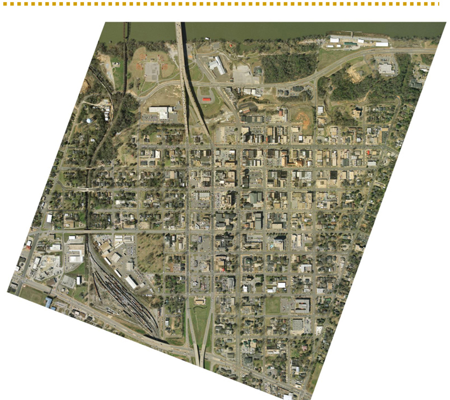
With the exception of two blocks, the street right-of-ways in the original Tuscaloosa are unchanged since 1821. (north boundary: the river; west boundary: Martin Luther King Boulevard to 15th Street: South Boundary: corner of 15th Street and MLK Boulevard to corner of Queen City Boulevard and 15th Street; east boundary: Queen City Boulevard from 15th Street to the river)
https://www.loc.gov/
I have a scan of the 1993 Union Furniture color version on file at Tuscablue and they can print HUGE copies at their cost. Please feel free to share any of this with those who may be interested.
I don't have a succinct narrative to describe HORNET ROW.
ANYWAYZZZZZZZZZZZZZZ...
If ya click on this blog post and scroll ALL THE WAY DOWN to where it says "Why do yon mountains turn the musing eye", you'll see the newspaper clipping that turned me on to HORNET ROWThe store PAUSE (2306 6TH STREET) is inside the old Leland Hardware store which is on part of the subdivision of Lot 166 which was the southeast corner of the block when it was first sold in 1821. Lot 166 is the northwest corner of Monroe Street (23rd Avenue which ends at the Drish House past 15th St. and if ya walk out there in the middle of 23rd Ave. and look south, you'll see the Drish House which was originally called Monroe Place and it was all named for President Monroe who ordered Lot 166 sold in October of 1821) and Cotton Street.
https://tile.loc.gov/storage-services/service/ll/llsl//llsl-c14/llsl-c14.pdf
with the section No. 16, further exception of such sections, not exceeding ten in number, as the sale, the President shall designate, for the purpose of laying out and establishing towns therein, be offered for sale to the highest bidder, under the direction of the register of the land office, and the receiver of public moneys, at the place where the land office is kept, and on such day, or days, as shall, by proclamation of the President of the United States, be designated for that purpose; the sales shall remain open two weeks, and no longer. The lands shall not be sold for less than two dollars an acre.
United States Public Land Survey was established by an act of Congress in 1785 in order to dispose of lands in the Western Territory of the new nation. In Alabama, two different surveys
were used to subdivide parcels of land. In the
northern half of the state, the Huntsville survey’s origin was established by the Huntsville Meridian
and Base Line which had begun to be surveyed in 1809. In the southern half of the state, the St. Stephens survey’s origin was established by the St. Stephens Meridian and Base Line.
The Freeman Line is not a base line, but rather where the Huntsville and St. Stephens surveys meet.
From the origins, gridded lines were established at 6 mile intervals. The east-west lines are called townships and the north-south lines are called ranges. The intersection of the gridded lines form rectangles of 36 square miles, also called townships. Each township is subdivided into 36 sections of approximately one square mile,and may be further subdivided into halves, quarters and the like."
So for North Alabama, the survey began in 1809 at the state line with Tennessee above Huntsville.
from https://www.huntsvilleal.gov/historicmarkers/initial-survey-point/
In 1809, Major Thomas Freeman, Deputy U.S. Surveyor, established a marker here on the state line, and began surveying south toward the middle of the state. The line, known as the Huntsville Meridian, is the reference for all property surveys in North Alabama. The Initial Point, now in the middle of the highway, was reset in 1977 by the Alabama Society of Professional Land Surveyors.
BECOMIN' PART OF THE HUMAN BLOB...uh, uh https://www.youtube.com/watch?v=SCg5VOaNz1s&list=RDSCg5VOaNz1s&start_radio=1&rv=SCg5VOaNz1s&t=3
Various Wellge Maps https://www.cartermuseum.org/artists/henry-wellge
PROJECT BIRD'S EYE VIEW: http://goodnightraleigh.com/2011/10/introducing-project-birds-eye-view/
Wellge's 1885 Pensacola Panoramic map https://www.pensapedia.com/wiki/Wellge_map
Koch's 1898 Pensacola Panoramic map https://www.pensapedia.com/wiki/Koch_map
Wellge's 1885 Birmingham Panoramic Map https://www.bhamwiki.com/w/1885_Henry_Wellge_map
John LaTourrette MAP OF THE STATE OF ALABAMA & WEST FLORIDA https://www.raremaps.com/gallery/detail/81466/la-tourrettes-map-of-the-state-of-alabama-and-west-florida-la-tourrette-cram
posted by robertoreg at 7:11 AM
![]()

0 Comments:
Post a Comment
<< Home